On this page
Within Walking Distance

Framlingham Castle (2¾ miles by foot)
One of the most impressive castles in England, dating from the 12th century. On 19 July 1553, Henry VIII's eldest daughter Mary was proclaimed Queen of England at Framlingham Castle. She became the first woman to be crowned queen of England in her own right, following the removal of Lady Jane Grey, the 'Nine-Day Queen'.Click on the photo to visit the English Heritage site for opening times, etc. including frequent special events. There is a charge to enter within the curtain walls, including the wall walk and museums. However, the massive earth works, mere and stunning surroundings are accessible at all times without charge.
Queen Mary's Lane (adjacent)
 This prehistoric trackway became the long straight boundary between the
'hundreds' of Parham and Plomesgate in early Anglo-Saxon times. Then,
during the events in 1553 described above, imagine yourself as a peasant
working the surrounding fields, when the Queen rides past, high on a
white horse leading an army of thousands on the way to London. This
would certainly warrant naming the lane after her.
This prehistoric trackway became the long straight boundary between the
'hundreds' of Parham and Plomesgate in early Anglo-Saxon times. Then,
during the events in 1553 described above, imagine yourself as a peasant
working the surrounding fields, when the Queen rides past, high on a
white horse leading an army of thousands on the way to London. This
would certainly warrant naming the lane after her.We maintain the length of Queen Mary's Lane through our farm as a permissive bridleway, enabling you to cycle off-road or walk to Framlingham (to the west) or to Great Glemham (to the east). Click or tap on the old map to see it full-sized and to find out more about the rich history of Queen Mary's Lane.

Woodland Trust, Pound Farm, Great Glemham (adjacent)
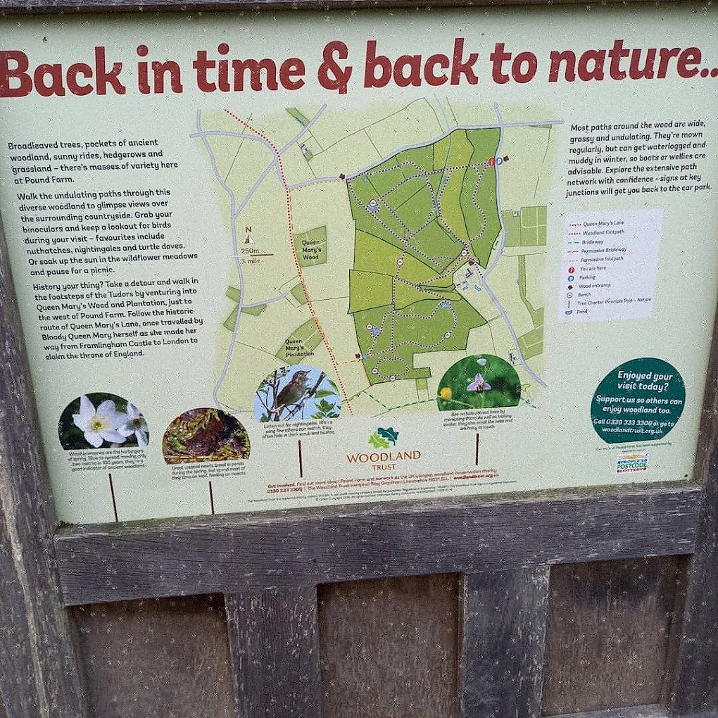
The Woodland Trust purchased Pound Farm in the 1990s, and planted it over with broad-leaf trees, adding to the pockets of old woodland already there. To access the Woodland Trust's site about Pound Farm, click on the photo.The old map linked above shows a 2.5 mile / 4km circular walk through Pound Farm that joins with the camp site along Queen Mary's Lane. You can follow the signposts and interpretation boards – starting with the one on the corner of the Nether Oaks camp site. See this photo of the Woodland Trust's interpretation board (now taken down) for plenty of other pleasant walks through their woods and meadows, and the locations of benches along the way.
 The Local Network of Footpaths and Bridleways
Click
or tap our map on the right, which highlights all the permissive
footpaths and
bridleways connecting the camp-site to the local rights of way and
onward to neighbouring villages. This is the only place you will find
many of them – they are often not on
other maps. 
openstreetmap is the best electronic map for route finding by foot or cycle. You can interactively drag the red and green 'map pins' to the start and end of your journey. It recognizes many of the permissive paths, but not yet all.
 The map on the left is a close-up that shows the permissive paths around the camp-site.
 Please don't stray from these paths and please respect the countryside code as usual.
 Local Pubs
You can use the bridleways mapped above to cycle or walk to nearby pubs
in three neighbouring villages (blue beer mugs on the map):
- Great Glemham Crown Inn (2 miles)
- Sweffling White Horse (3¼ miles)
- Rendham White Horse (3¾ miles)
As well as the four pubs in Framlingham (about 3 miles – see 'Visit Framlingham' below).
 Visit Framlingham (2¾ miles by foot)
A well as the castle, Framlingham offers pubs, shops, eating out and
pleasant walks. Click or tap on the picture to access the 'Visit
Framlingham' site.A Little Further Afield
 The Suffolk Coast (about 13 miles away)
You'll generally find fairly sandy beaches from Thorpeness northward –
click or tap on the photo of Southwold beach to be taken to the Suffolk
Beach Guide.
|
|||
 Boating on Thorpeness Mere (13 miles)Visit this quirky mock Tudor village including the House in the Clouds – all created by the eccentric Glencairn Stuart Ogilvie in the Edwardian era, from what had been just a small fishing village. |
|||
|
|||
|
|||
You can spend the day queuing at Aldeburgh's famous fish and chip shop
(the Golden Galleon down the street is is run by the same people and the
queue's usually shorter), or buy fish to cook yourself from the sheds
on the beach. Many other things to do in Aldeburgh – click or tap the
picture for some ideas from a local. |
|||
The Anglo-Saxon royal ship burial ground. The National Trust visitor
centre exhibits the awe-inspiring artefacts found by the self-taught
archaeologist Basil Brown in 1939. |
|||
Across the river from Sutton Hoo, on Woodbridge quay, you can visit the
Longshed where the ninety-foot ship in which King Raedwald was buried at
Sutton Hoo is being reconstructed using Anglo-Saxon techniques and tools. You will find volunteers
at hand to answer all your questions. |
|||
Just across the quay from the Sutton Hoo Ship Project, this rare mill is
still regularly producing flour 850 years after it was built as one of
the earliest tide mills in the country – and now one of only a handful
left in the world. You can climb up into all the floors to see the
mechanism in action, with volunteers always on hand to explain
everything. |
|||
|
|||
 Minsmere (12 miles)The range of habitats at Minsmere makes it a special place for bird spotting, with reedbeds, grassland, heathland and the wild coast. |
|||
|
|||
 The ever-shifting coastline at remote Shingle Street (17 miles)Whenever you visit, the pools and banks at Shingle Street are mysteriously no longer quite the same as before. Nonetheless, good beach-combing is always a constant. |
|||
Area of Outstanding Natural Beauty. Stretching from Southwold down to
Old Felixstowe, taking in Walberswick, Blythburgh, Dunwich, Minsmere,
Thorpeness, Aldeburgh, Orford, Shingle Street and Bawdsey. |
|||
East Suffolk is renowned as a foodie area, with much locally grown
produce sold from the farm gate or at small farm shops, cafés and
restaurants. For instance Garnett's Gardens in Hacheston (2 miles), the Farm Café+Shop at Marlesford (5 miles), Friday Street farm shop & café (6 miles; pictured here), the organic Maple Farm Shop in Kelsale (8 miles), Emmerdale Farm Shop in Darsham (9 miles), Grange Farm Shop in Hasketon (11½ miles),... the list goes on and on. |
|||
WWII museum on Parham Aerodrome, including the museum of the secret British Resistance Organisation. |
|||
All sorts of farm animals and pets to experience, and to handle if at
all possible; some little ponies can be ridden on. Rides in carts or
towed behind a quad bike. Original milking dairy, Excellent play area
including mastering a digger arm, and a large bouncy thing. Café and
soft play area indoors. |
|||
Nearby Walks |
|||
|---|---|---|---|
Find 27 brass markers in the pavement on a short trail around the centre
of Framlingham. Each indicates an interesting sight to spot.
|
|||
A pleasant (and sometimes a bit muddy) walk around the 12 hectare Suffolk
Wildlife Trust Reserve with stunning views of Fram Castle and Fram
College |
|||
Taking in Moat Hall, Parham Church, Parham
Wood and Parham's three greens (Long route 1h 40mins; Short 1h). |
|||
A
lovely walk across country from Wickham Market Station (in Campsea
Ashe) to Framlingham. Courtesy of Suffolk On Board. It passes about 1 mile away from the camp-site by foot. |
|||
Local Walks based around the Sweffling White Horse pub, which is 3¼ miles away by foot. |
|||
The Brownsord Way connects up nearly 12 miles of public rights of way
encircling Framlingham, 90% of which is off-road. |
|||


